HoloCollab
Overview
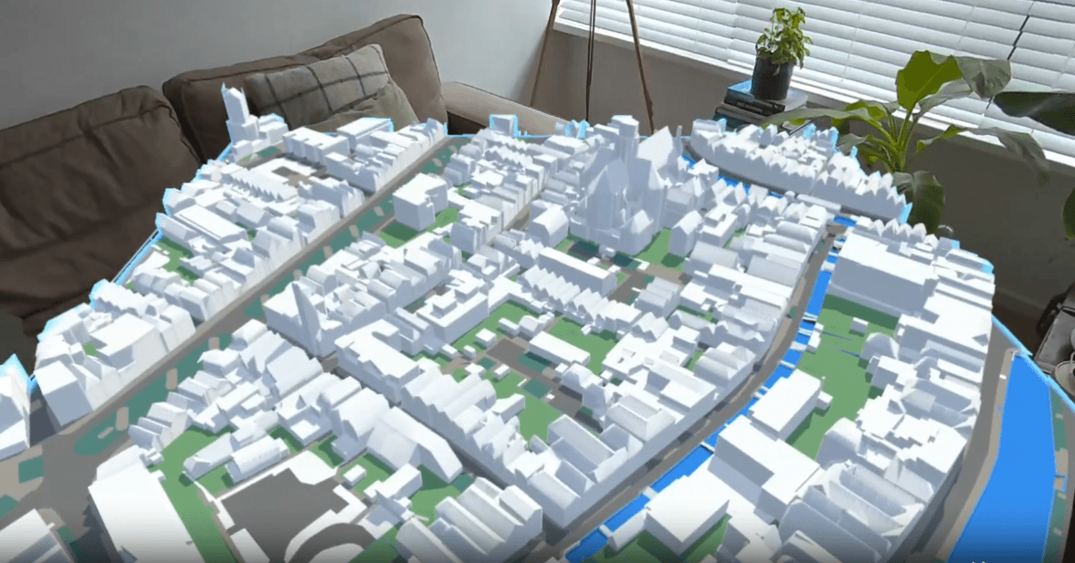
HoloCollab is a mixed-reality digital twin platform designed for municipal spatial planning. It allows planners, designers and stakeholders to step inside a 1:1 scale, georeferenced 3D model of a neighbourhood or project site, together, in real time, using the Meta Quest 3.
The project ran as a funded feasibility study under MG Interactive, exploring whether mixed reality could meaningfully improve spatial understanding and collaborative decision-making within Dutch municipalities.
The Challenge
Municipal spatial planning processes rely heavily on 2D maps, technical drawings and CAD renderings. These formats work well for specialists, but consistently fall short when communicating spatial proposals to a broader group of stakeholders like aldermen, community members, or cross-departmental teams.
- • Stakeholders struggle to form an accurate mental model of a spatial proposal from 2D representations
- • Misalignment between technical teams and decision-makers leads to costly late-stage revisions
- • Public participation tools rarely convey scale, context, or spatial relationships effectively
- • Review cycles often require on-site visits just to build a shared baseline understanding
A Recurring Pattern
Across interviews and surveys with spatial planning professionals at multiple Dutch municipalities, a consistent signal emerged: a lack of spatial insight among non-technical stakeholders is a structural bottleneck in planning processes. This was one of the clearest and most consistent findings from our research.
The Solution
HoloCollab places stakeholders inside a live, georeferenced mixed-reality environment built from real geospatial data. Using the Meta Quest 3, multiple participants can inhabit the same virtual space, walk through proposed designs at true scale and interact with layered planning data, bridging the gap between technical datasets and human spatial intuition.
Prototype Demo
Technology Stack
Technologies
Technical Research
A significant part of the project involved evaluating different approaches for visualising large-scale geospatial data in mixed reality. This included in-depth research into:
- • ArcGIS Maps SDK for Unity - evaluation of performance and integration capabilities
- • OGC 3D Tiles - assessment of open standards for streaming tiled 3D geospatial content
- • Custom data pipelines for PDOK and 3DBAG integration
- • Performance optimization strategies for real-time MR rendering
Validation
The feasibility study combined technical research, market research, user testing and structured interviews with municipalities and spatial planning professionals. The results offered a clear picture of both the platform's strengths and the conditions required for broader adoption.
✓ Technical Feasibility
The integration of real-world geospatial data (PDOK, 3DBAG) into a performant mixed-reality environment was successfully demonstrated. The technical stack proved viable for the intended use case at a meaningful level of fidelity.
✓ Usability
User testing confirmed that participants, including non-technical stakeholders, could navigate and interpret the MR environment with minimal onboarding. Spatial comprehension gains were immediate and tangible across test sessions.
◎ Market Timing
Interviews and surveys showed clear added value, but the problem-solution fit sits at the edge of current market readiness. Mixed reality as a planning tool is still perceived as novel and municipal procurement and organisational processes are not yet structured to adopt it at scale.
Conclusion
HoloCollab demonstrated genuine added value. Technically sound, user-friendly and addressing a real and documented problem. The primary barrier to adoption is not the technology itself, but the pace at which public-sector organisations can adapt to integrate spatial computing into their workflows. The platform is a few years ahead of its time.